

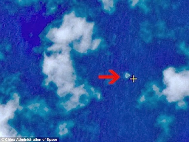
Satellite images released by the Chinese authorities now show possible aircraft wreckage 141 miles from its last known radar location and very close to where a New Zealand oil rig worker reported seeing a plane going down.
After massive speculation which included the rejection of Michael McKay’s report from the Songa Mercur rig south east of the Vietnamese port city and holiday resort of Vung Tau – this area is now the main target of search operations.
But the satellite images were taken three days ago and the wreckage is likely to have drifted considerably and maybe even broken up completely. It might be optimistic to now expect positive results of a surface search of the sea. The United States which should have more sophisticated imaging has not as yet commented.
ABC reports now however that McKay confirmed his report made through his employers Idemitsu Oil & Gas Co who were utilizing the Norwegian owned rig.
Doan Huu Gia, deputy general director of Vietnam’s air traffic management confirmed authorities had received the email from Mike McKay, a New Zealander working on a rig operated by the Italian Oil Company ENI in the Gulf of Thailand.
“He said he spotted a burning [object] at that location, some 300 km (200 miles) southeast of Vung Tau,” said the Vietnamese official.”
But later Vietnamese officials were reported as giving little credit to the report.
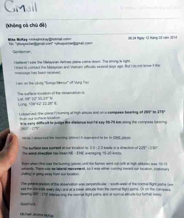
But McKay’s email sent the morning after the plane went missing gave a detailed account. He was on the rig Songa Mercur when he saw the aircraft in flames. His email reads.
‘Gentlemen. I believe I saw the Malaysian Airlines flight come down. The timing is right.
“I tried to contact Malaysian and Vietnamese officials days ago. But I do not know if the message has been received.
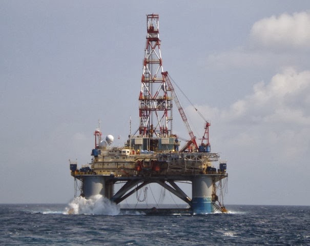
“I am on the oil ring Songa-Mercur off the coast of Vung Tau.
‘The surface location of the observation is Lat 08* 22’ 30.20” N
Lat 108* 42.22.26” E
“I observed (the plane?) burning at high altitude at a compass bearing of 265* to 275*
‘It is very difficult to judge the distance but I would say 50 to 70 kms along the compass bearing 260-277.
While I observed (the plane) it appeared to be in one piece.
“The sea surface current at our location is 2-2.3 knots in the direction of 225-230.
“The wind direction has been E-ENE averaging 15-20 knots.
“From when I first saw the burning (plane?) until the flames went out (at high altitude) was 10-15 seconds.
“There was no lateral movement so it was either coming toward our position stationary (falling) or going away.
“The general position of the observation was perpendicular/ south west of the normal flight paths. (We see the con trails every day) and at a lower altitude than the normal flight paths or on the compass bearing 265 to 275 intersecting the normal flight paths at normal altitude but further away.
“Good Luck”
Michael Jerome McKay”


The surface location of the observation is Lat 08* 22’ 30.20” N
Lat 108* 42.22.26” E
Looks legit.
Could be legit. Sounds like it.
What are the coordinates of the Songa Mercur? Is it drilling or being towed?